2022-10: Lowest to Highest (L2H), Pt. 3
- Feb 12, 2023
- 11 min read
From Cerro Gordo, perched high in the Inyo, we could see Mt. Whitney. If all went according to plan, we'd be there in 48 hours. We'd wind north along the crest of the mountains until we were even with Lone Pine, then descend into the Owens River Valley via Long John Canyon. We'd cross the valley, ascend to Whitney Portal, and then summit the following day. We could see the finish-- how hard could it be?


Whitney is center of the grayest peaks, with a prominent dip off its right shoulder.
We got a slow start, waiting for the sun to come out-- I wasn't ready to mess around in 18 degree weather in short shorts, and neither was anyone else. We also wanted to see how much it was going to warm up. According to the plan, we'd remain at 10,000 feet for the next 15 miles or so, keeping in the bitter cold. We filled up from our cache with shaking hands, pouring water into bottles, breaking up the ice chunks. The sun was nice, but it wasn't doing enough. Someone got service-- the high, at our elevation, would barely crack 40. It didn't feel on track to be warmer.
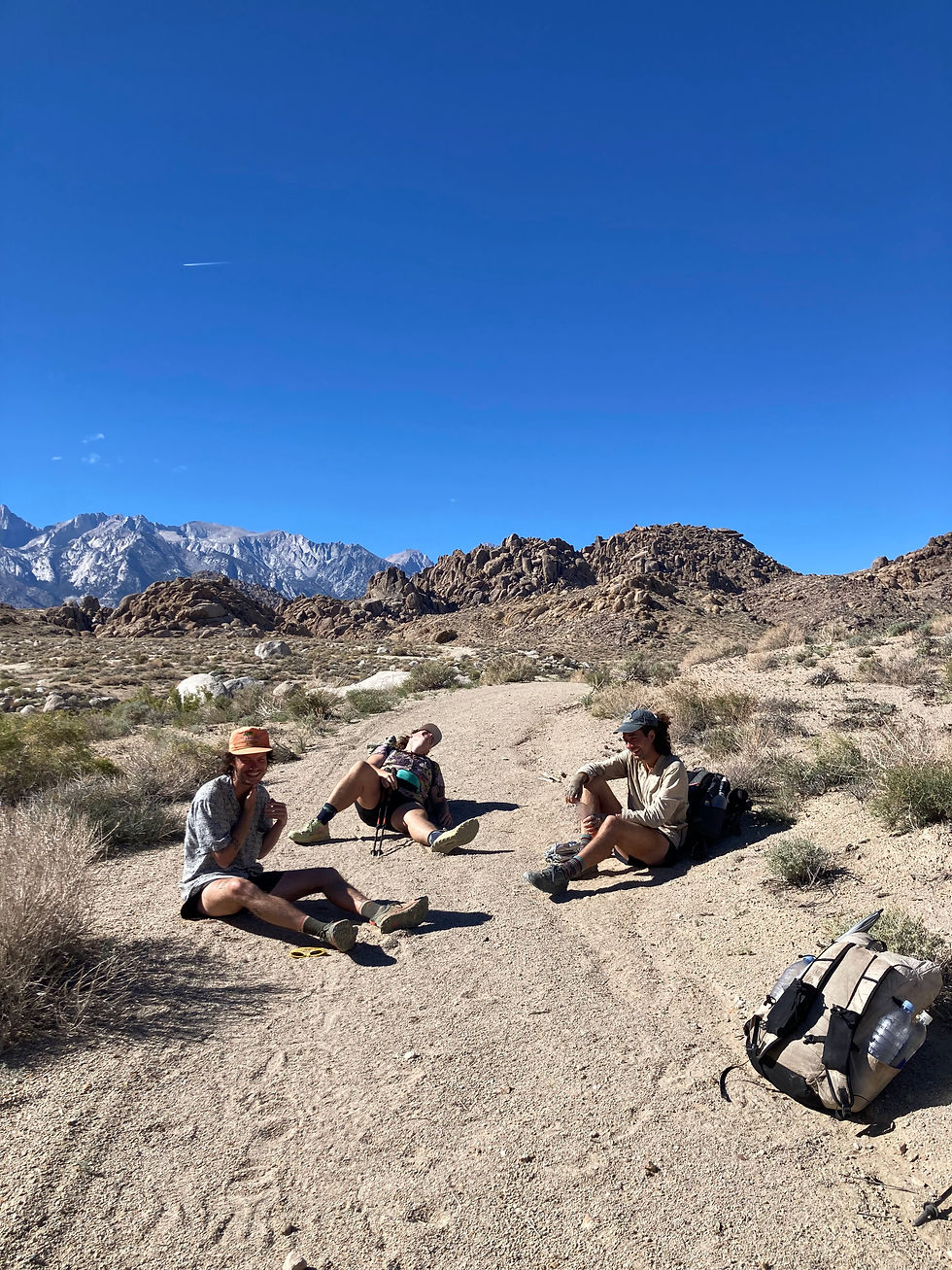
We were tired of freezing-- the unexpected cold weather had thrown a wrench in the last few days, and we'd had some miserable nights. We decided without much heartache to take the Cerro Gordo road down to the valley immediately, and roadwalk into town on the highway. We'd miss some official route miles, but keep our continuous footpath. The water carry into Lone Pine was also one of the longest of the trip, and without beta on Long John, we weren't feeling great. We needed some kind of victory.

The valley was flooded with the recent rain-- I'd never seen it like this before. The pools reflected the sunlight, making the valley floor glisten and shine when the angle was right. It was dazzling. As we made our way some 6,000 ft down the mountains, we had no shortage of opportunities to take in the view, but it somehow never got old. I can look at the Eastern Sierra forever-- the dramatic rise can only be truly felt in person, with Whitney's summit towering almost 12,000 feet above the town of Lone Pine. We had a long way down to go, and then a long way up. But the weather was warming, the wind had calmed, and spirits were high. It was obvious we'd made the right choice.
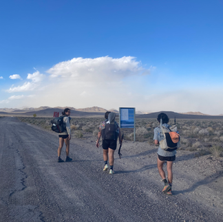
We got happier and happier as we descended and the day heated up. It wouldn't be sweltering, the high along the road wasn't supposed to break the mid-80s. A welcome and comfortable change of pace from the trip to date. But the gravity of what a 25 mile roadwalk looked like wasn't quite apparent until we were staring it in the face.

Frisbee and umbrella on full display as we send it down the highway
I was worried we'd get bored, or angry, or frustrated, or wistful that we were missing the Inyo crest. And maybe all of these feelings were present in trace amounts-- but even in the moment, we were having a blast. Looking back now, it was easily the silliest day of the trip, and one of the most fun. A few stray cars pulled over on the 2-lane, checking in on us. Most of the walk was completely devoid of... well, anything, really. The Sierra on your left, the Inyos on the right, and a whole lot of asphalt and desert in between.
We found garbage-- a golf ball, a discarded computer chip, an abandoned traffic cone. We found uses for everything. We tossed the frisbee. We shot the shit. We listened to podcasts, or music, or the wind. We waxed philosophical. We walked in complete silence. We got service, and checked in on friends. Shitless had returned to San Diego, feeling really sick. Turns out she'd gotten the flu. She asked if things were going according to plan-- well, not exactly. We got hit by a sandstorm, caught like 3 hitches, almost froze to death, and now we're roadwalking 25 miles to Lone Pine. With how bad the trip sounded, I think she, justifiably, felt consoled in her decision to bail.


Another one of Lobster's infamous tan lines; rocks & the road.
A car pulled over, someone waving and yelling. It was Mads' friend from Portland, caching water before they started, 4 or 5 days behind us. L2H is an uncommon route: I'd seen evidence of 2 other groups throughout. I'd seen a water cache for someone named Frog while I was caching, and the two hikers we'd met at the Portal when dropping the car. That was already a busy year. For there to be 4 groups in a week, and have 2 groups have any kind of connection at all is either a testament to how small & weird the thru-hiking community is, or an act of fate, or both. We gave our beta "it's been crazy, and so cold and so hot and so windy", wished them luck, and kept on our way. We'd hear later that they'd make the same bail off of Cerro Gordo that we had.
Asphalt tends to wear on the feet, and as the day wore on, we all started to get a bit sore. We planned to scope out camping options in Lone Pine as we got closer-- we had a few options, many of which a group member had stayed at previously. We argued the merits of one random park or baseball dugout against another, and we pressed on. Plenty of daylight, plenty of miles before we had to worry about that.


We scoped out the McDonalds in town, and counted down the miles-- eight. Five. Two left. Three miles go by. No McDonalds. A miscalculation on distance-- another two miles. The sun goes down-- headlamps on as we walk facing into the traffic on the 395, semitrucks flying by. We get beers from the gas station a mile out of town, and joyously run toward the shittiest burgers known to man. This is followed by a second dinner at the local burger restaurant-- fine dining-- for the pretentious purists (me), and to cover the obscene amount of food we all need. Finally, we pile into a motel room all together, victims of advertising-- one of the very few things we'd seen on the 136 was an advertisement for the Dow Villa. We'd caved.
This next day would be easy, just getting up a handful of miles to Whitney Portal, so we got a slow start out of town. A real breakfast together, then splitting off to all our favorite spots in town. Lone Pine has a special place in my heart, and it likely does for most folks who've spent significant time in the eastern Sierra, or resupplied on the PCT. I visited my favorite coffee shop, bakery, bookstore, and gear store, to pick up some additional layers for the Whitney summit. The summit was looking clear, but with a high below freezing, and very windy. You can see clear to the summit, from the town. It's striking even you're driving all the way up. We would, of course, be walking.
We finished our respective nostalgia trips, reconvened, and started the approach to the Portal.

The infamous rock face in Alabama Hills; L-R Handy, Lobster & Me
The road is long. And steep. And a little warm. Much of the route follows community trails-- a little loop behind some houses, a half mile of hardpack-- and our sore feet were feeling it. We lounged, secure in the small number of miles to cover, and the impossibility of pushing further than the Portal. Lobster thought she might hitch up if the hitch looked good-- and who should pull over but Devin, our savior from several days prior. He was driving down to town for supplies, but if Lobster was still trying when he came back, she had a guaranteed ride. Comfortable with the certainty, Hand Me Down, Mads and I headed up the old Whitney trail, hardly used since the road had been built.

The road makes a single big switch just above Handy's umbrella, the trail follows the slope up the left-hand side of the same valley

The trail was in good shape, but I was pretty beat from the day before. We made good time, but I lagged behind the group a little on the ascent. Some days you feel strong, others you don't! All told, the climb to the Portal was brief, pretty, and uneventful. We found Lobster outside the store-- it was cold at altitude. Having passed through the last low-elevation portion of the trip, it would only be colder from here on out.
We finally retrieved our cold-weather gear from the car, and set up camp for the summit day. Despite having done the climb several times, and in harder conditions, I was nervous. We could wake up to stormy skies, or snow. And there was no way to know until the morning.
We awoke long before dawn to the beeping of watches and stirring of others. For day trippers, we got a late start, probably on trail by around 6 or so-- I truly don't recall anymore. The energy was high, and once we got moving, we warmed up pretty quick.
It was late enough in the season that there was no chain of headlamps up the slope, just a few solitary lights blinking in the darkness from miles on up ahead. We encountered almost nobody for the first bit.

As the sun came up, the sky brightened above the Inyos-- we talked about the mountains beyond, tucked out of sight, the Panamints, Darwin Plateau, the Cottonwoods, and somewhere, the Funerals, with Badwater Basin nestled below them. It was incredible to think back on the distance and challenges we'd faced. The terrain today was comparably easy.
Even with the sun, it remained cold, and I was glad for the layers I had, after all the days of suffering. We climbed, with most of the smaller water sources largely frozen. The marsh below Outpost Camp was a frosty tundra, the usual mecca at Outpost devoid of people. The late-season conditions had driven away the crowds.
As we took a breather, perched on a rock outcropping with an exceptional view of the valley, we heard falling rocks behind us. We turned around to search for the sound, ready to cover for a rockslide, but instead, a bighorn ram came down the slope at full speed-- I had never seen one before. We stayed perfectly still, though he was well aware of us. Probably faster than I could run, he traversed down near-vertical sections of rock before disappearing into the brush. And the silence rushed back in, like it never happened.


On the climb toward Trail Camp, Lobster was feeling rough. The altitude, the elevation changes of the last few days, the cold, the incessant climbing, blisters-- the list of valid grievances could go on for days. She wasn't feeling up to the summit push-- we'd need to move fast to avoid the risk of bad weather up top, and to prevent coming down in the dark. We talked over it at Trail, and she made the hard call to turn back. She'd gotten what she needed from the trip-- crossed Death Valley over difficult terrain, carving a path through one of the least hospitable places on earth. She didn't need something like a 5th Whitney summit-- it hadn't been the point for her.

We were well above the treeline, now, and the route traveled through stark alpine lakes and granite. Consultation Lake was a frigid-looking ice blue. The three of us charged up the 99 switchbacks, in the few hours of sunlight they would get that day. The skies were clear, the weather tolerable, and the stoke was high.

The climb passed quickly, and before long we were at the crest. On the east side, where we'd climbed, the earth fell precipitously down toward Lone Pine, the town visible only as glimmers of light, the sun reflecting off windows. To the west, the backcountry-- towering granite ranges, chains of lakes, all my favorite places: the Kaweah range visible, Crabtree at our feet, the trail toward Whitney picking its way neatly below the ridgeline, among the crumbling talus.

Post-gratuitous photo op on my favorite ledge at the crest
The last mile or two the summit, we felt the thin air. We'd climbed 12,000 feet in 24 hours, not acclimating at all to the challenge. We walked, little dizzy, lightheaded, fatigued, toward the end of our adventure. It was Mads' first Whitney summit, and they led the group. The switchbacks got flatter and flatter, and before long we had reached the summit register and the hut.

By some kind of luck, it was clear and windless at the summit-- at least for a while. It was frigid, but we were soaking in the feeling of what we'd accomplished. What a dumb trip. What a stupid thing for anyone to do. We made some friends, who were universally concerned with us upon hearing where we'd come from. We held a forget-me-not ceremony for Lobster and Shitless, signed the register, and scrounged through our packs for the dregs of our snacks. A few gummy worms. Some loose nuts. One cracker. There was, eventually, nothing to do but go back down. We were aided in this by the cold, and the chilling wind that was blowing in. We'd been out of water for a while-- the lake was frozen-- and we were looking forward to town food. It'd be a photo finish with the sunset, and my headlamp was dead. I used my battery to keep my camera charged even as the frigid temps conspired against me. How lucky to get bonus miles even after achieving our goal?

We charged down the switchbacks, often icy, and now completely shaded. We saw Devin and his group-- their summit day was tomorrow-- and we stopped to chat for a while, exchange stories and beta and thanks. Our trip could've looked very different without his help, trapped somewhere around the Panamint store, miles behind schedule.
After Outpost, I pushed on ahead, since I didn't want to be stuck out without a light in the dark. I jogged down the majority of the way (Therapy isn't that expensive, yelled a hiker), and took a small detour to visit Lone Pine Lake and take in the pastel sky. I encountered a lost hiker-- he was ok, but asked me to notify his group that he was on his way. His friends had left him half a day earlier, close to the summit. He would end up safely walking out of the wilderness, much to everyone's relief. But by the time I got to the Portal, folks had gone to town to alert emergency services. All was well.

Still a mile or two from the car, the light fading fast
The last half hour was run in the dark, trace amounts of light from the faint glow of the ending sunset. A fitting way to end the trip. Taking corners on two poles and at full speed as I had for years before, I finally snapped a pole in half. Another fitting end. I found Lobster outside the store, trying to stay warm. Mads & Hand Me Down weren't far behind, and we wasted no time in getting off the mountain-- despite my parking ticket. We'd crash for the night at a climber's camp, say our goodbyes to the Eastern Sierra for the season, and head home the next day.

So, how to summarize? I'm not sure. It didn't go smoothly, that should be clear. I have sections to revisit before my plans for next year kick off. I'd like to take a stab at Tuber Canyon, maybe Darwin. If I'm feeling incredibly bored and resourceful, maybe I'll hitch up to Cerro Gordo, walk to Lone Pine along the crest, as intended. But at the same time, I did what I needed to do. The makeup miles don't feel like makeup miles, they feel like a bonus. Setting out across the salt flats with nothing ahead but question marks, that was the fun. Executing one of the largest single climbs in the US, surviving the logistics nightmare that is Death Valley, walking across the barren, beautiful, inhospitable, lovely desert, weathering the absurd changes in the environment-- choosing to subject myself to all of this and somehow coming out on top, that was the point for me. To demonstrate to myself the limits of what I could do. And to have a chill, easy trip with friends. Somehow, both?
The one thing I do know is that I'll be back. Lowest to Highest is a special route through some special places, and I'm excited to revisit it, as much as anyone can ever revisit anything.
Bonus pictures:

The celebration of recovering our cold-weather gear after days of freezing

Nostalgia Trip: Hand Me Down's first-ever Trail Camp site, ten years ago


Panorama Slider at Badwater, just before starting out


Friends <3


Comments